
GPS Receivers
GPS Receivers
HI-204III USB
Ultra High Sensitive
USB GPS Receiver
WATERPROOF
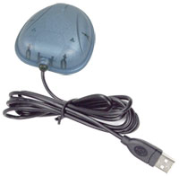 HI-204III-USB is a GPS receiver with USB interfaces and built-in active antenna for high sensitivity to tracking signal. HI-204III-USB is well suited to system integration and users who use any kinds LaptopPC. It satisfies a wide variety of applications for car navigation, personal navigation or touring devices, tracking and marine navigation purpose. Users can simply plug it into a LaptopPC running with suitable mapping and routing software for navigation.
Standard Package :
Before you start up, make sure that your package includes the following items. If any items are missing or damaged, contact your dealer immediately.- HI-204III-USB GPS Receiver unit
- User Manual CD (including User Manual, HaiTest Testing Program)
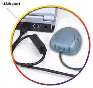
For notebook PC use:
HI-204III-USB connect with a LaptopPC USB port.OVERVIEW :
Fast Acquisition Enhanced Sensitivity 20 Channels “All-In-View” Tracking GPS Sensor Module.
he receiver continuously tracks all satellites in view and provides accurate satellite positioning data. The HI-204III-USB is optimized for applications requiring good performance, low cost, and maximum flexibility; suitable for a wide range of OEM configurations including handhelds, sensors, asset tracking, PDA-centric personal navigation system, and vehicle navigation products.
It's 20 parallel channels and 4000 search bins provide fast satellite signal acquisition and short startup time. Tracking sensitivity of -159dBm offers good navigation performance even in urban canyons having limited sky view.
Satellite-based augmentation systems, such as WAAS and EGNOS, are supported to yield improved accuracy.
FEATURES :
- 20 parallel channel GPS receiver
- 4000 simultaneous time-frequency search bins
- SBAS (WAAS, EGNOS) support
- -159dBm tracking sensitivity
- < 8 second hot start
- < 40 second cold start
RECEIVER OPERATION :
Upon power up, after initial self-test has completed, the HI-204III-USB will begin satellite acquisition and tracking process. Under normal open-sky condition, position-fix can be achieved within approximately 35 seconds (within 10 seconds if valid ephemeris data is already collected from recent use). After receiver position has been calculated, valid position, velocity and time information are transmitted through the on board serial interface.
The receiver uses the latest stored position, satellite data, and current RTC time to achieve rapid GPS signal acquisition and fast TTFF. If the receiver is transported over a large distance across the globe, cold-start automatic-locate sequence is invoked. The first position fix may take up to 50 sec searching the sky for the GPS signal. The acquisition performance can be improved significantly if the host initializes the receiver with a rough estimate of time and user position.
As soon as GPS signal is acquired and tracked, the HI-204III-USB will transmit valid navigation information through its serial interface. The navigation data contains following information:
- Receiver position in latitude, longitude, and altitude
- Receiver velocity
- Time
- DOP error-magnification factor
- GPS signal tracking status
The HI-204III-USB will perform 3D navigation when four or more satellites are tracked. When three or fewer satellites are tracked, altitude-hold is enabled using the last computed altitude and 2D navigation mode is entered.
With signal blockage or rising and setting of the satellites, where a change in satellite constellation used for position fix occurred, large position error may result. The HI-204III-USB incorporates a proprietary algorithm to compensate the effect of satellite constellation change, and maintains an accurate smooth estimate of the receiver position, velocity, and heading.
Technical Specifications: Electrical Characteristics
| Items | Description | |
| Chipset | GSP3F | SSiRF Star IV technology |
| General | Frequency | L1, 1575.42 MHz |
| C/A code | 1.023 MHz chip rate | |
| Channels | 20 | |
| Accuracy | Position | 10 meters, 2D RMS |
| 5 meters 2D RMS, WAAS corrected | ||
| <5meters(50%), DGPS corrected | ||
| Velocity | 0.1 meters/second | |
| Time | 1 microsecond synchronized to GPS time | |
| Datum | Default | WGS-84 |
| Other | selectable for other Datum | |
|
Acquisition Rate (Open Sky & Stationary Requirements) |
Reacquisition | 0.1 sec., average |
| Snap start | 1 sec., average | |
| Hot start | 8 sec., average | |
| Warm start | 38 sec., average | |
| Cold start | 42 sec., average | |
|
Dynamic Conditions |
Altitude | 18,000 meters (60,000 feet) max. |
| Velocity | 515 meters/second (1000 knots) max. | |
| Acceleration | 4g, max. | |
| Jerk | 20 meters/second3, max. | |
| Power | Main power input | 5V DC input. |
| Power consumption | 0.38 W (continuous mode) | |
| Supply Current | 75mA | |
| Backup power | 3 V Lithium-Ion rechargeable battery | |
| Dimension | 43mm L x 42mm W x 13mm H | |
| Weight | 23g | |
LED Indicator
| LED flashing 0.25Hz | Signal Searching |
| LED flashing 1Hz | Position Fixed |